Contact | RSS | EN | DE | EL | ES | FR | IT | RU

Volcans à Sumatra (68)

Barus | Bekulap | Belirang-Beriti | Besar | Bukit Daun | Bukit Lumut | Bukit Lumut Balai | Bukit Nanti | Bukit Telor | Bukit Tenaroh | Bukit Tiga | Dempo | Geureudong | Geureugoh | Gunung Sembuang | Gunung Telago | Gunung Tudeuk | Helatoba-Tarutung | Hulubelu | Hulunilo | Hutapanjang | Imun | Isau-Isau | Kaba | Kembar | Kerinci | Lubukraya | Maninjau | Marapi | Martimbang | Masurai | Melintang | Nama Salah | Olim | Patah | Pendan | Pesagi | Pesawaran-Ratai | Peuet Sague | Pulau Weh | Raja | Raja-Sabanda | Rajabasa | Ranau caldera | Runcing | Sarik-Gajah | Sekincau Belirang | Seulawah Agam | Seulawah Inong | Sibayak | Sibualbuali | Simbolon | Sinabung | Sorikmarapi | Sukadana Basalts | Sumbing | Suoh | Takur-Takur | Talakmau | Talang | Tandikat | Tanggamus | Telong | Teu Minas | Toba | Tujuh | Tungkat | Uruk Simacak
[plus petit] [plus gros]

Volcano list

Barus

(Stratovolcano 1969 m / 6460 ft)
[plus d'info]

Bekulap

(Lava dome(s) ? 1782 m / 5846 ft)
[plus d'info]

Belirang-Beriti

(stratovolcano )
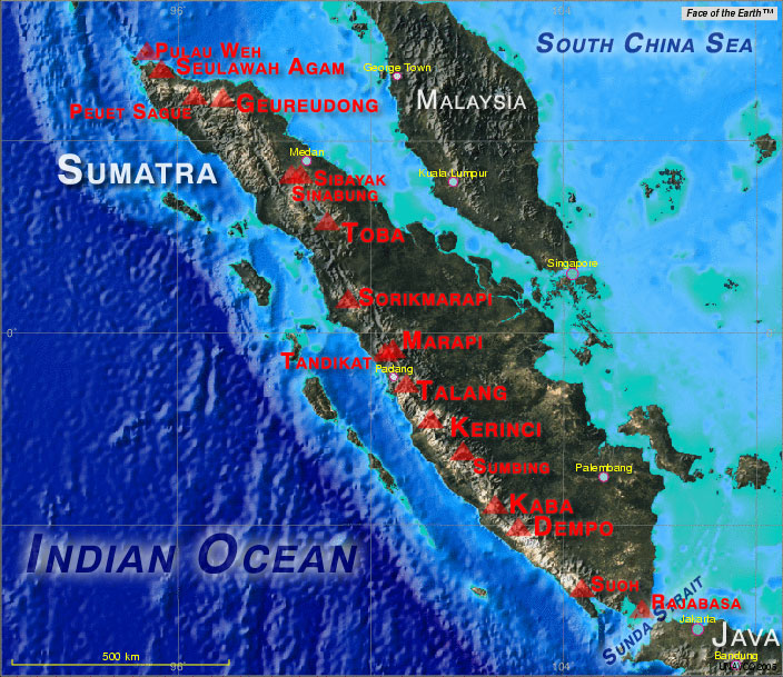
The compound Belerang-Beriti volcano rises above the Semalako Plain in SW Sumatra, forming a NW-SE-trending massif that contains a 1.2-km-wide crater breached to the NE. [plus d'info]

Besar

(stratovolcano 1889 m)
Gunung Besar is a 1899-m-high volcano in SE Sumatra with a minor sulfur deposit in its crater. [plus d'info]

Bukit Daun

(stratovolcano 2467 m)
Located in a sparsely populated region of Sumatra, Bukit Daun forms a twin volcano with Gedang volcano. [plus d'info]

Bukit Lumut

(Stratovolcano 1738 m / 5702 ft)
[plus d'info]

Bukit Lumut Balai

(stratovolcano 2055 m)
Bukit Lumut Balai is a heavily eroded volcano consisting of three eruption centers, two on Bukit Lumut and one on the NE side of Bukit Balai, 5 km to the east. Large lava flows occur on the north side of Bukit Balai. [plus d'info]

Bukit Nanti

(Unknown 1619 m / 5312 ft)
[plus d'info]

Bukit Telor

(Pyroclastic cone 38 m / 125 ft)
[plus d'info]

Bukit Tenaroh

(Unknown unknown)
[plus d'info]

Bukit Tiga

(Stratovolcano 1629 m / 5344 ft)
[plus d'info]

Dempo

(Stratovolcano 3173 m (10,410 ft))
Dempo is a prominent 3173-m-high stratovolcano that rises above the Pasumah Plain of SE Sumatra. [plus d'info]

Geureudong

(Stratovolcano 2885 m (9,465 ft))
The massive Bur ni Geureudong volcanic complex, one of the largest in northern Sumatra, consists of the two adjacent volcanoes of Bur ni Geureudong and Bur ni Telong. [plus d'info]

Geureugoh

(Fissure vent(s) unknown)
[plus d'info]

Gunung Sembuang

(Explosion crater unknown)
[plus d'info]

Gunung Telago

(Unknown 1930 m / 6332 ft)
[plus d'info]

Gunung Tudeuk

(Lava dome unknown)
[plus d'info]

Helatoba-Tarutung

(fumarolic field 1100 m)
Helatoba-Tarutung, located in northern Sumatra south of Lake Toba, is a group of sulfurous hot springs along a 40-km-long, NNW-SSE-trending stretch of the Renun-Toru fault zone. [plus d'info]

Hulubelu

(stratovolcano 775 m)
Hulubelu is an elliptical, 4-km-long caldera or volcano-tectonic depression in SE Sumatra. [plus d'info]

Hulunilo

(Stratovolcano 2469 m / 8100 ft)
[plus d'info]

Hutapanjang

(stratovolcano, caldera 2021 m)
Huatapanjang stratovolcano, located to the NW of Sumbing volcano, is classified as active by Rock et al. (1982) and Posavec et al. (1973), with no additional information. Little is known of this central Sumatran volcano. It is not sure if the 2009 6.8 R earthquake was connected t... [plus d'info]

Imun

(lava dome 1505 m)
Imun is a single small dacitic and/or rhyolitic cone south of Lake Toba with a youthful, undissected morphology, and is considered to be of late-Pleistocene or Holocene age (Aldiss et al., 1983). Source: Smithsonian GVP [plus d'info]

Isau-Isau

(Unknown 1422 m / 4665 ft)
[plus d'info]

Kaba

(Stratovolcano 1952 m (6,404 ft))
Kaba, a twin volcano with Mount Hitam, has an elongated summit crater complex dominated by three large historically active craters trending ENE from the summit to the upper NE flank. [plus d'info]

Kembar

(stratovolcano 2245 m)
The Gayolesten fumarole field is located on the flanks of the Pleistocene Gunung Kembar volcano. [plus d'info]

Kerinci

(Stratovolcano 3800 m / 12,467 ft)
The 3800-m-high Gunung Kerinci in central Sumatra is Indonesia's highest volcano and one of the most active in Sumatra. [plus d'info]

Lubukraya

(stratovolcano, lava dome 1862 m)
Lubukraya is a well-defined andesitic stratovolcano of latest Pleistocene to possibly Holocene age with a broad crater breached to the south and a prominent lava dome at the southern foot of the volcano (Aspden et al. 1982). [plus d'info]

Maninjau

(Caldera 1724 m / 5656 ft)
[plus d'info]

Marapi

(Stratovolcano 2891 m (9,485 ft))
Gunung Marapi (not to be confused with the better-known Merapi volcano on Java) is Sumatra's most active volcano. [plus d'info]

Martimbang

(Stratovolcano 1669 m / 5476 ft)
[plus d'info]

Masurai

(Stratovolcano 2916 m / 9567 ft)
[plus d'info]

Melintang

(Stratovolcano 2262 m / 7421 ft)
[plus d'info]

Nama Salah

(Unknown unknown)
[plus d'info]

Olim

(Fissure vent(s) unknown)
[plus d'info]

Patah

(stratovolcano )
Patah is a heavily forested, dissected Quaternary volcano SE of Dempo volcano. [plus d'info]

Pendan

(stratovolcano 1631 m)
Pendan is a little-known volcano in central Sumatra that is listed as an active volcanic center by Rock et al. (1982) and Posavec et al. (1973), with no additional information. Source: Smithsonian GVP [plus d'info]

Pesagi

(Unknown 2232 m / 7323 ft)
[plus d'info]

Pesawaran-Ratai

(Stratovolcano 1575 m / 5167 ft)
[plus d'info]

Peuet Sague

(Complex volcano 2801 m / 9,190 ft)
Peuet Sague is a large volcanic complex that rises to 2801 m in NW Sumatra. [plus d'info]

Pulau Weh

(Stratovolcano 617 m / 2,024 ft)
[plus d'info]

Raja

(Unknown 1643 m / 5390 ft)
[plus d'info]

Raja-Sabanda

(Unknown 2527 m / 8291 ft)
[plus d'info]

Rajabasa

(stratovolcano 1240 m)
Rajabasa is a prominent, isolated volcano along the Sunda Strait at the SE-most tip of Sumatra. [plus d'info]

Ranau caldera

(stratovolcano, caldera 1880 m)
Ranau is an 8 x 13 km caldera volcano in southern Sumatra partially filled by the crescent-shaped Lake Ranau. Gunung Semuning is a potentially still active stratovolcano constructed at the SE side of the caldera. [plus d'info]

Runcing

(Unknown 1789 m / 5869 ft)
[plus d'info]

Sarik-Gajah

(Pyroclastic cones )
The Sarik volcanic andesitic/basaltic center consists of two young cones with vegetated, but uneroded surfaces. [plus d'info]

Sekincau Belirang

(stratovolcano )
Sekincau volcano was constructed near the southern rim of the small NW-SE-trending double Belirang and Balak calderas, 2 and 2.5 km wide, respectively. [plus d'info]

Seulawah Agam

(Stratovolcano 1810 m / 5,938 ft)
Seulawah Agam is an active stratovolcano at the northwestern tip of Sumatra. It was built within the older lam Teuba caldera. It has a 400 m wide forested summit crater and a crater at 650 m on the NNE flank, the Van Heutsz crater, which has active fumaroles. The last activity of... [plus d'info]

Seulawah Inong

(Unknown 730 m / 2395 ft)
[plus d'info]

Sibayak

(stratovolcano 2212 m)
Sibayak volcano belongs to the Singkut caldera in northern Sumatra. It represents one of several cones that grew on or near the southern caldera rim after its formation. [plus d'info]

Sibualbuali

(stratovolcano 1819 m)
Sibualbuali is an eroded Pleistocene stratovolcano with two solfatara fields on the eastern flank. [plus d'info]

Simbolon

(Stratovolcano 1509 m / 4951 ft)
[plus d'info]

Sinabung

(Stratovolcano 2460 m (8,071 ft))
Sinabung volcano in July 2015
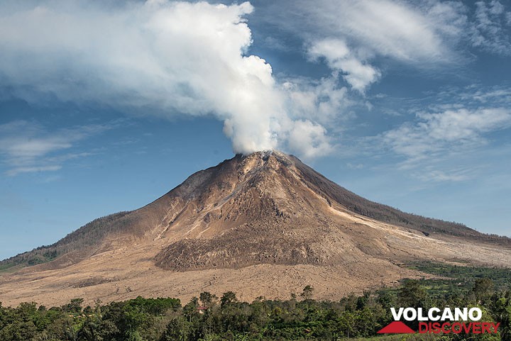
Sinabung is a typical stratovolcano in northern Sumatra next to the town of Berastagi. [plus d'info]

Sorikmarapi

(Stratovolcano 2145 m (7,037 ft))
Sorikmarapi is a forested stratovolcano with a 600-m-wide summit crater containing a crater lake and substantial sulfur deposits. [plus d'info]

Sukadana Basalts

(Fissure vent 300 m / 984 ft)
[plus d'info]

Sumbing

(Stratovolcano 2507 m (8,225 ft))
Smaller than its prominent namesake on Java, Sumatra's Sumbing volcano has a complicated summit region containing several crater remnants and a 180-m-long crater lake. [plus d'info]

Suoh

(Maar 1000 m (3,281 ft))
The 8 x 16 km Suoh depression appears to be primarily of tectonic origin, but contains historically active maars and silicic lava domes along its margins. [plus d'info]

Takur-Takur

(Unknown 1499 m / 4918 ft)
[plus d'info]

Talakmau

(stratovolcano 2919 m)
Talakmau (also known as Talamau) is a massive compound volcano rising above the western coastal plain of Sumatra. [plus d'info]

Talang

(Stratovolcano 2597 m / 8,520 ft)
Talang, which forms a twin volcano with the extinct Pasar Arbaa volcano, has two crater lakes on its flanks. [plus d'info]

Tandikat

(Stratovolcano 2438 m (7,999 ft))
Tandikat and its twin volcano to the NNE, Singgalang, lie across the Bukittinggi plain from Marapi volcano. [plus d'info]

Tanggamus

(Stratovolcano 2079 m / 6821 ft)
[plus d'info]

Telong

(stratovolcano 2617 m / 8,586 ft)
Telong (or Bur ni Telong) volcano is a conical stratovolcano built at the southern base of the massive Bur ni Geureudong volcanic complex, one of the largest in northern Sumatra. The historically active volcano lies 4.5 km from the summit of Geureudong, and its summit crater has ... [plus d'info]

Teu Minas

(Stratovolcano unknown)
[plus d'info]

Toba

(Caldera 2157 m (7,077 ft))
Toba volcano has produced the largest known volcanic eruption on earth during the past 2 million years. [plus d'info]

Tujuh

(Stratovolcano 2732 m / 8963 ft)
[plus d'info]

Tungkat

(Unknown 1576 m / 5171 ft)
[plus d'info]

Uruk Simacak

(Stratovolcano 1908 m / 6260 ft)
[plus d'info]

Le Volcanisme sur Sumatra

Le volcanisme de Sumatra est une conséquence de la subduction vers le Nord-est de la plaque océanique indo-australienne sous la plaque continentale de la Sonde (une subdivision tectonique de la plaque Eurasienne) avec une progression allant jusqu'à 70 mm/ans.
La région est tectoniquement parmis les plus actives de toute la planète Terre, enregistrant de très forts séismes de fortes magnitude, comme le grand séisme de magnitude 9.0 (ou peut être même de 9.3) le 26 décembre 2004, qui a malheureusement été illustré.
Les volcans les plus actifs de Sumatra sont le Marapi et le Karinci, suivi par les volcans Talang et Kawa.
Carte tectonique simplifiée de l'Océan Indien et de Sumatra, avec les mouvements de la plaque tectonique, la fosse de la Sonde, la localisation du grand séisme de 2004, et les volcans de Sumatra. (USGS)
  • Page d'actualités des Volcans de Sumatra

Les Volcans de Sumatra (Indonésie)

Les volcans actifs majeurs de Sumatra. (La base de la carte a été créé à l'aide d'outil cartographique UNAVCO mettant en fond la face de la Terre)
Les volcans actifs majeurs de Sumatra.

Découvrez notre app gratuite !
Volcanoes & Earthquakes - new app for Android
Android | Version iOS

Plus sur VolcanoDiscovery

Why is there advertising on this site?

Support us - Help us upgrade our services!

We truly love working to bring you the latest volcano and earthquake data from around the world. Maintaining our website and our free apps does require, however, considerable time and resources.
We need financing to increase hard- and software capacity as well as support our editor team. We're aiming to achieve uninterrupted service wherever an earthquake or volcano eruption unfolds, and your donations can make it happen! Every donation will be highly appreciated. If you find the information useful and would like to support our team in integrating further features, write great content, and in upgrading our soft- and hardware, please make a donation (PayPal or Online credit card payment).

Planned features:Thanks to your past donations, these features have been added recently:
Download and Upgrade the Volcanoes & Earthquakes app to get one of the fastest seismic and volcano alerts online:
Android | IOS
Thank you!
Copyright: VolcanoDiscovery ou autres sources indiquées.
Utilisation des documents: Les textes, les images et les vidéos de ce site internet sont protégées par copyright. Toute reproduction et tout usage sans accord préalable ne sont pas autorisés. Si vous désirez acquérir pour certains documents (photos, vidéos, textes ou autres) le droit de reproduction, d'édition et, plus généralement, de toute utilisation destinée à un usage public, qu'elle soit commerciale ou pas, vous êtes priés de nous contacter.
Volcanoes & Earthquakes
VolcanoDiscovery Home
Volcans | Séismes | Photos | Actualités | App
Adventure & Study Travel
Tours to Volcanoes and Volcanic Areas: walking tours, photo tours, study tours
Voyages |
Get our newsletter!
Company info
Contact | Mentions légales | Terms & conditions
Follow us
Follow us on facebook Follow us on Instagram Follow us on Twitter Visit our Youtube channel
EN | DE | EL | ES | FR | IT | RU
VolcanoDiscovery GmbH, Germany, Reg. nr.: HRB 103744, EU Tax Id: DE 297 465 123 owned and created by
Dr. Tom Pfeiffer, volcanologist, volcano photographer, tour organizer member of
IAVCEI
IAVCEI
Vulkanologische Gesellschaft
Volcanological Society
Ecotourism Greece
Ecotourism Greece
RUV insurance
Insured by R+V
VolcanoDiscovery © 2004- All Rights Reserved | Privacy